 Sourced,
 Conflicts
 Prices From
 01Getting There
 02East or West Coast
 03When to Go
 04Where to Stay
 05Diving
 08Beaches
 09The Kettle Drum
 10Gantarang Lalang Bata
 12Selayar Tarsier
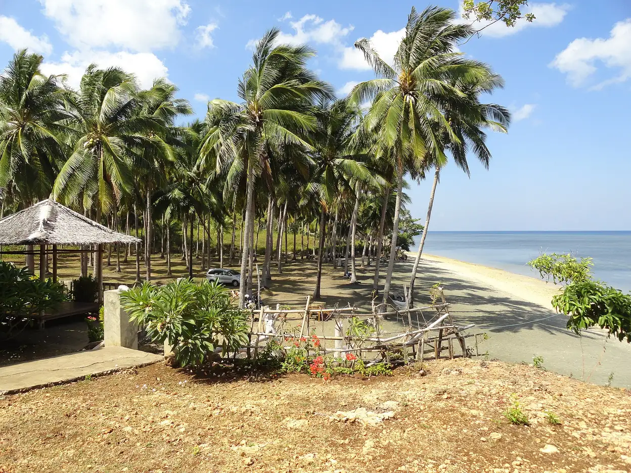
 Coconut palms line a beach on the west coast of Selayar Island, South Sulawesi.
 A thatched bungalow beside a beach on the west coast of Selayar Island.
 Calm water seen from under a thatched roof at a beach bungalow on the west coast of Selayar Island.
 A remote sandbank near Pulau Bahuluang, off the southern end of Selayar Island.
 Clear shallow water along a beach on the west coast of Pulau Pasi, off Selayar Island.
 An outrigger boat in the shallows off a beach on Pulau Pasi, about a mile from the west coast of Selayar Island.
 Interest stated openly
On this page
- What is Selayar Island?
- Where is Selayar Island and how big is it?
- How do you reach Selayar Island?
- How do you get around Selayar Island?
- Which coast should you choose, and when?
- What can you do on Selayar Island?
- Who is Selayar Island a poor fit for?
- What else do travellers ask about Selayar Island?
- Which sources support this page?
- How do I reach the desk?
By Selayar Island Editorial Desk
Selayar Island, or Pulau Selayar in Indonesian, is an 80 km long, mostly rainforest island off Cape Bira in South Sulawesi, reached by a short flight from Makassar or by road and ferry. It has east-coast dive walls, the Nekara drum and white-sand beaches, and the regency counted only 195 foreign visitors in 2022. This guide compares the coasts and routes and says who should skip it.
What is Selayar Island?
Selayar is the main island of the Selayar Islands, in South Sulawesi Province, and the Selayar Straits divide it from the mainland, as Wikipedia sets out. Indonesia's Ministry of Tourism describes it as 80 km long and predominantly rainforest, with many white-sand beaches. UNESCO names the Selayar people as the major group on the island, living alongside Bugis, Bajo, Buton and ethnic Chinese communities, with fishing the principal livelihood and tourism second.
Very few foreign travellers make the trip: the regency's tourism master plan counted 195 in 2022, and our page on where to stay on Selayar Island gives the fuller visitor and room counts. Foreign arrivals peaked at 1,068 in 2019, so services are sized for a trickle of outsiders, and the journey has little slack in it.
Where is Selayar Island and how big is it?
The island lies off the southwestern tip of Sulawesi. Britannica calls it the largest of its island group and names Benteng as the main port, while Wikipedia's archipelago article puts the group about 150 km southeast of Makassar. In round terms it is long and thin, and Wikipedia notes that it narrows sharply at both the northern and southern ends.
On size, the ministry and Wikipedia give a length of 80 km, while Indonesia Expat calls it 100 km. Wikipedia gives an area of 798.58 sq km and Britannica 899 sq km, and we do not merge them. Our explainer on where Selayar Island is sets each figure beside its source and separates the island from the regency, which are easy to confuse. About 90,000 people live in the six main-island districts, on mid-2025 estimates.
How do you reach Selayar Island?
Two routes matter. One is a short flight from Makassar to H. Aroeppala Airport (KSR), about 7 km from Benteng. The other is overland from Makassar to Bira, a ferry to Pamatata, then a road down the island to Benteng. Sources quote different times for most legs, so the table keeps them apart.
| Leg | Published time | Who says so |
|---|---|---|
| Flight, Makassar to Selayar | About 45 minutes | Sulawesi.com, a tour operator's guide |
| Road, Makassar to Bira | 4 to 5 hours | Wikipedia |
| Ferry, Bira to Pamatata | About 2 hours | ASDP Bira, quoted by Tribun-Timur, July 2026 |
| Ferry, Bira to Pamatata | 2.5 hours | Sulawesi.com |
| Road, Pamatata to Benteng | 90 minutes | Sulawesi.com |
| Road, Pamatata to Benteng | About 1 hour | TurtlePhD, one traveller's blog, undated |
| Overnight ship, Makassar to Benteng | About 9 hours | Selayar tourism office, May 2021 |
Treat the flight as the fragile option. Wikipedia reports that only FlyJaya operates scheduled services as of 2026, while Trip.com and Rome2Rio name other airlines and other frequencies. Sulawesi.com records two stoppages since 2023, dated on our Makassar to Selayar flight page. The sea has its own risk: the same operator's travel guide says the afternoon boat is regularly cancelled in rough weather.
Rome2Rio also says no direct ferry runs from Makassar, yet the regency's tourism office reported a private overnight ship, KM Dharma Kartika III, starting Makassar to Benteng sailings in April 2021, and Journey Beyond the Horizon, a travel blog dated October 2025, still lists it once or twice a week. Ask its operator, DLU, for the current days before counting on it. The full walk-through, with published fares, is on our page about how to get to Selayar Island.
How do you get around Selayar Island?
By hired scooter, hired car or a car with a driver. Journey Beyond the Horizon says there are no public buses with timetables, and that one main road runs from Pamatata down the west side to Appatanah, with branches off it. The east coast has no through road, only short branches that reach certain points. Those authors found a single car-rental firm in Benteng and could not get a car because its one or two vehicles were out, while scooters were easier to find through a hotel. For a full day out to Appatana, which the regency plan puts 52 km from Benteng, line up a driver through your lodging before the day itself.
Which coast should you choose, and when?
Choose the coast by the month. Wikipedia describes west wind sending big waves onto the west side from October to March, and east wind doing the same to the east side from April to September, so one side is usually the calmer choice. Operators' calendars broadly follow that split, though not to the exact week; our page on the best time to visit Selayar Island compares them.
| Coast | Calmer months (Wikipedia) | What sources describe | The catch |
|---|---|---|---|
| West | April to September | Benteng, the road, local warungs and stores (TurtlePhD); Baloiya beach about 11 km from town (regency plan) | The town side is where people live, so it is the less secluded coast |
| East | October to March | A central chain sloping steeply to the shore (Wikipedia); Pinang beach and dive resort walls (operators) | TurtlePhD reports no cell service, no Wi-Fi and most places reached by boat |
Sulawesi.com says most visitors stay in Benteng, and TurtlePhD suggests starting there before heading east. That order lets you check the sea, arrange transport and buy what you need in town first. The trade-offs of each side are on our east coast vs west coast page.
What can you do on Selayar Island?
The fuller list, with distances, is on our page of things to do in Selayar Island.
- Dive. The Ministry of Tourism groups Selayar's dive sites into East Selayar Beach, West Selayar Beach and Takabonerate. Sulawesi.com says Benteng operators run trips to wall and reef sites on the south coast. See Selayar Island diving for who runs what.
- Find a beach. The regency lists many, some by road and some only by local boat. Our guide to Selayar Island beaches sorts them by access.
- Follow the Nekara drum. Kompas says the Selayar Nekara is claimed as one of the world's largest, while the ministry simply calls it the largest. Ask locally whether the drum itself is on view; its measurements and find story are on the Selayar kettle drum page.
- Walk old villages. Start with Gantarang Lalang Bata and Bitombang village.
- Cross to an islet. Pasi Gusung Island is about 30 minutes by lepa boat from Benteng, in a 2016 report.
- Look for wildlife, without promises. UNESCO lists hawksbill and green turtle, common dolphin, napoleon fish, sperm whale and short-finned pilot whale in the Taka Bonerate-Kepulauan Selayar Biosphere Reserve, nominated in 2015 at 4,410,736 ha. A species list is not a sighting forecast.
Who is Selayar Island a poor fit for?
Skip it if your trip has no slack. A missed sailing or a suspended flight can break a tight connection in Makassar, and neither route has the depth of service that gives you an easy second chance.
It also suits you poorly if you need steady signal for work, want a long strip of resorts and restaurants, or expect year-round access to one fixed base. Seasonal closure is real: Selayar Dive Resort says it shuts outside October to the end of April because of the monsoon. Divers who want a chamber close by should note that the same operator says the nearest recompression chamber is in Makassar; our page on whether Selayar Island is safe covers health and sea risks.
The few beach properties are compared on our Selayar Island resort page, and published fares and rates are gathered under Selayar Island travel cost.
Very short visits rarely make sense either. Our Selayar Island itinerary starts from the stay length a tour operator's guide recommends, rather than from a weekend.
What else do travellers ask about Selayar Island?
What is Selayar Island like?
Long, narrow and mostly forested, with white-sand beaches on the published descriptions, one main town at Benteng and a small visitor economy. Services thin out quickly beyond town, especially on the east coast.
What is Selayar Island known for?
Mainly its dive walls, its Nekara drum, old hill villages, the Selayar tarsier and a place on the old spice route. Kompas reports that ships bound for Maluku passed through the Selayar Strait and stopped for water, supplies and repairs.
Is Selayar hot throughout the year?
Largely, yes. A table published by Sulawesi.com gives daytime highs from 28 C in July and August to 31 C from October to December. Rain, rather than heat, is what changes most through the year.
Is Selayar Island good for couples?
It can be, for couples who want quiet beaches and accept few facilities and a slow journey. Selayar Eco Resort and Pearl Beach Cottage describe six and four units on their own pages, while the regency says most hotels are small and in Benteng.
Why should you visit Selayar Island?
For east-coast walls, quiet beaches and history that runs from a Dongson drum to Dutch copra warehouses. Do not go expecting polished services or a reliable timetable: Sulawesi.com records two flight stoppages since 2023 and regular cancellations of the afternoon boat in rough weather.
Which sources support this page?
- Wikipedia: Selayar Island
- Indonesia Ministry of Tourism: Selayar
- UNESCO: Taka Bonerate-Kepulauan Selayar Biosphere Reserve
- Selayar regency tourism master plan (RIPPARKAB 2023-2025)
- Britannica: Selayar
- Wikipedia: Selayar Islands
- Wikipedia: Selayar Islands Regency
- Wikipedia: H. Aroeppala Airport
- Tribun-Timur, July 2026
- TurtlePhD (traveller blog): Selayar
- Trip.com: Makassar to Selayar route page
- Rome2Rio: Makassar to Selayar Island
- Sulawesi.com (tour operator): Selayar Island destination page
- Sulawesi.com (tour operator): Selayar Island travel guide
- Indonesia Ministry of Tourism: Diving Selayar Island
- Kompas, November 2023: spice route traces in Selayar
- Selayar Dive Resort: rates
- Selayar Dive Resort: diving
- Indonesia Expat: sea turtles, the Selayar marine conservation challenge
- Selayar tourism office, May 2021: KM Dharma Kartika III
- Journey Beyond the Horizon (travel blog, October 2025): Selayar Island guide
How do I reach the desk?
Selayar Island is a travel guide under Juara Holding Group with a request desk. It does not run boats, rooms, tours or schedules. Requests through the desk can lead to a paid booking, so we have a commercial interest. Any fee, the price and the company that would contract with you are set out in a written offer before you agree to anything, and only that offer binds. Contact: WhatsApp +62 811-3941-4563 or bd@juaraholding.com. Read the disclaimer for how figures on this site are handled.
Send the desk your dates, group size, and what you want to do. The desk replies in writing.
Ask the desk on WhatsApp bd@juaraholding.com